

Submitted by Dorothy Falk
Sources:
"Illinois Place Names", Compiled by James N. Adams, 1969, plus addendum (can get through Illinois Library Loan System).
Names of Places
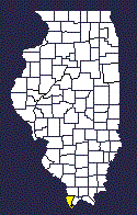
Wayne Co., IL and surrounding areas
Settlements, Villages,
Towns, Townships,
Prairies and Creeks
Partial List
AID - Post office established on 2 Jun 1873, discontinued 19 Apr 1876, reestablished 7 Nov 1879, discontinued 27 Mar 1880, reestablished 25 Apr 1882. Name was changed to Orchardville on 16 Jan 1891.
ARRINGTON - Town now known as Sims - Originally laid out in 1882 on land owned from John Simms. Post office established that year. Located in Section 9, T2S, R6E. On the Louisville, Evansville & St. Louis Railroad.
ARRINGTON PRAIRIE - The prairie is about ten miles long and two or three miles wide, almost completely in Arrington Township. Named after Charles Arrington, one of the first settlers in the area.
ARRINGTON TOWNSHIP - T1S, R6E. Named after the Prairie.
BAREFOOT - In Leech Township - The region north of Golden Gate before the settlement of Golden Gate. The people went barefoot to save their shoes. Named after a fight where a local guy was barefoot and an outsider wore socks.
BARN HILL - On the Baltimore and Ohio Railroad . Post office established as Barnhill.
BARNHILL - Post Office established 10 Feb 1871, still active in 1961, population count was 60. On the Baltimore and Ohio Railroad line as Barn Hill.
BARNHILL TOWNSHIP - Named for the settlement.
BEAR PRAIRIE - Same as Shipley's Prairie - Five miles east of Fairfield, on the west side of the Little Wabash. Had twenty families in 1836.
BEDFORD TOWNSHIP -T1N, R7E.
BEECH BLUFF - Post office established 30 Jul 1886, name changed to Golden Gate on 18 Oct 1888, now known as Goldengate. It is on a bluff and there were probably beech trees there in the earlier years.
BENNINGTON - Rural Free Delivery West Salem. Population 50. Rand McNally 1958 map erroneously gives this as Edwards County instead of Wayne County.
BERRY TOWNSHIP -
BIG CREEK - The creek is in the extreme southeast corner of Leech Township and flows into the Wabash. Named because of the simplest description that early settlers could give it.
BIG MOUND TOWNSHIP - T2S, R7E.
BIG MOUND PRAIRIE - Now Boyleston. Five miles west from Fairfield, three miles in extent, undulating surface, thin soil. In 1836 had about fifty families.
BLACK OAK - Post Office established 27 Sep 1853, discontinued 16 Oct 1861.
BLUE POINT - Post Office established 28 Dec 1854, discontinued 15 Apr 1863.
BOYLESTON - Post Office established 27 Nov 1882, discontinued 31 Jan 1927. Now RFD Fairfield. On Southern Railroad. Formerly Big Mound Prairie. Population in the 1958 Rand McNally atlas was 50.
BRIAR BRANCH - In Leech Township, area south of Golden Gate. Named because of all the briars and brambles, name then applied to the creek, too.
BRUSH CREEK- Post Office established 22 Sep 1858, discontinued 2 Oct 1867.
BRUSH CREEK TOWNSHIP - T1N, R5E. Now divided into Garden Hill Township and Orchard Township.
BRUSHY PRAIRIE - On the east side of the Little Wabash, eleven miles east of Fairfield. In 1836, contained about fifty families.
BURNT PRAIRIE - Extends into Wayne County from the northwestern part of White County. It is about two miles in diameter, contains some good land and a dense settlement. The post office and town are in White County.
BUZZARD ROOST - Some boys gave this name to a church north of Liberty. When that church moved away, some gave the name to Antioch Church, but that name has been almost forgotten.
CAMPBELL - Listed in the Rand McNally 1956 Atlas but not in their 1958 Atlas. RFD Fairfield. On the Southern Railroad .
CAMPBELL HILL - A high hill at the edge of the bottoms in Section 4, T3S, named after James Campbell.
CASTOR - Post office established when name was changed from Riverton on 20 May 1874, discontinued on 16 Apr 1890, reestablished 21 Jan 1891, and discontinued 15 Dec 1900.
CINCINNATI - Shown in state atlas in 1876.
CISNE - Post Office established 6 Jan 1871, still active. RFD serves Enterprise and Round Prairie. Incorporated as a village on 15 Jan 1898. On Baltimore and Ohio Railroad. Population in 1960 was 615. Population now about 2,000.
CLARKSON - Post office established on 12 Jan 1891 and discontinued 30 Jun 1902.
COIL - Post Office established 10 Mar 1903, discontinued 15 Jun 1906.
COVINGTON - Listed in Rand McNally Atlas in 1956 but not in their 1958 Atlas. RFD Fairfield. Formerly Pin Oak.
CRISP - Post Office established 11 Mar 1899, discontinued 14 Nov 1905. Now RFD Wayne City. Population in Rand McNally�s 1958 Atlas was 35.
CROSS ROADS - Post Office established 19 Jun 1863, discontinued 6 Jul 1866.
DEVIL'S HALF ACRE - In Leech Township, between Golden Gate and the river. Named because some local men used to gather and play cards there.
EGYPT - In the southeast part of Leech Township, the region below the "vee" formed where Big Creek flows into the Little Wabash. Natives seldom crossed over the river into the other areas. Residents were called Egyptians. Same area also called Lower California.
ELLERY - Part Wayne County, part Edwards County. Post Office established in Edwards County on 15 May 1882, still active. On Southern Railroad . Formerly Linesville. Population shown in the 1958 Rand McNally map was 80. Named after the railroad right-of-way surveyor. First choice of name for the town was Linesville but there was already a Linsville in the state.
ELM RIVER- Small stream in Wayne and Clay Counties.
ELM RIVER TOWNSHIP - T1N, R8E.
ENTERPRISE - Post Office established 15 Jun 1849, discontinued 30 Sep 1907. Now RFD Cisne. Population shown in Rand McNally 1958 Atlas was 35.
FAIRFIELD - Post Office established when name was changed from Wayne Courthouse on 25 May 1820, still active. RFD serves Boyleston, Campbell, Covington/Pin Oak, Hubbard and Merriam. Incorporated as a city on 31 Jan 1840. Includes Highland Park, North Fairfield, Wayne Courthouse. On the Baltimore and Ohio Railroad and the Southern Railroad. Population in 1960 was 6,362. Population on Illinois 2000 map is 5,442. In 1836, contained three stores, one tavern, one court house and about 25 families. Large quantities of castor oil were manufactured.
FARMER'S LICK -
FOUR MILE TOWNSHIP - T2S, R5E and R6E.
FROG ISLAND -
GARDEN HILL TOWNSHIP - Part of the formerly Brush Creek Township.
GARDEN PRAIRIE -
GEFF - Post Office established when name changed from Jeffersonville on 11 Aug 1917, still active. On the Baltimore and Ohio Railroad. Incorporated as Jeffersonville.
GOLDEN GATE - Post Office established when name changed from Beech Bluff on 18 Oct 1888. Name was further changed to Goldengate on 23 Feb 1895. Incorporated as a village on 14 May 1897 as Golden Gate. Railroad shows as Goldengate. Population in 1960 was 156. Possibly named because one man refused to give the right for the railroad to cross his land. He had gates on his porch to keep stock off. One day he took down the gates, the house was moved, the railroad continued. Some say that money was paid and called it the Golden Gate.
GOLDENGATE - Post Office established when name changed from Golden Gate on 23 Feb 1895, still active. On the Southern Railroad. Incorporated as Golden Gate.
GOODLAND - Post Office established 24 Apr 1902, discontinued 15 Nov 1904.
GROVER TOWNSHIP -
GUM - Post Office established 9 Feb 1903, discontinued 31 Jan 1906. Not the same as Gum Corner.
GUM CORNER - Not the same as Gum. In Leech Township. Named because it was a corner where roads met and there were gum trees there.
HARGRAVE'S PRAIRIE - Adjoins Fairfield, about seven miles long and two miles wide. Rolling land, thin soil. Population in 1836 was about one hundred families.
HERRINGTON'S PRAIRIE - Eight or eleven miles northwest of Fairfield. It is eight miles long, from two to four miles wide, surface rolling, soil second rate. In 1836, there were about fifty families.
HICKORY HILL PRAIRIE -
HICKORY HILL SETTLEMENT -18 miles west of Fairfield on the west side of Skillet Fork. It is a mixture of timber and prairie, soil second quality. Population in 1836 was about 50 families.
HICKORY HILL TOWNSHIP - R1S, R5E. Named after the Hill in the northwest part of the township which previously was covered with a heavy growth of hickory timber.
HIGHLAND PARK - Now part of Fairfield.
HOME - Post Office established 25 Feb 1863, discontinued 25 Aug 1882, reestablished 2 May 1884, discontinued 15 Dec 1898.
HOPKINS GROVE - Post Office established 3 Apr 1856, discontinued 6 Oct 1859. Named for Carlisle C. Hopkins, Postmaster.
HUBBARD - RFD Fairfield. On the Baltimore and Ohio Railroad.
HUNTSINGER HILL - In Leech Township - A high point in Section 25 named after the family that settled there in the earlier days.
INDIAN PRAIRIE - Post Office established 18 Oct 1854. Discontinued when name changed to Johnsonville on 23 Mar 1858. Reestablished in addition to the Johnsonville post office on 29 Jun 1893, discontinued on 25 Sep 1894.
Ten miles northwesterly from Fairfield. Surface is level, soil of an inferior quality. In 1836, this scattered settlement had about 15 or 20 families.
INDIAN PRAIRIE TOWNSHIP - T1S and T1N, R6E. Named in honor of a tribe of Indians who lived in this beautiful land many years ago.
JASPER TOWNSHIP - T1S, R8E. Named in honor of the indomitable Sergt. Jasper, of the Revolutionary war.
JEFFERSONVILLE - Post Office established 8 May 1857, changed to Geff on 11 Aug 1917. Jeffersonville incorporated as a village on 27 Mar 1907. On the Baltimore and Ohio Railroad as Geff. Population in 1960 was 330.
JOHNSON'S PRAIRIE -
JOHNSONVILLE - Post Office established on 23 Mar 1858 when name changed from Indian Prairie, still active. Incorporated as a village on 27 Nov 1897. Population in 1960 was 96.
KEENES - Post Office established on 11 May 1903 when name changed from Six Mile, still active. RFD serves Echoville, Keenesville, Keenville, Shields and Stratton. Incorporated as a village on 16 Jun 1958. On the Southern Railroad. Population in 1960 was 114.
KEENESVILLE - Listed in Rand McNally Atlas in 1956 but not in their 1958 Atlas.
KEENVILLE - Listed in the Rand McNally 1956 and 1958 Atlases. Discontinued 15 Sep 1906. RFD Keenes. Population 20.
KEITH TOWNSHIP
KENDALL - Post Office established 15 Jul 1837, discontinued 3 Feb 1841.
KING CREEK - Creek in the extreme northwest corner of Leech Township that was named after a family that lived in that area.
LAMARD TOWNSHIP - T1S, R7E.
LEECH TOWNSHIP - Named after Samuel Leech who operated a mill on the Little Wabash.
LEET HILL - In Leech Township, west of the river on the old stage coach trail. Named after the family that lived there.
LEMARDE PRAIRIE - Prairie 7 miles north west of Fairfield, about six miles long and three miles wide. Land of inferior quality. In 1836, there was only a small population.
LINESVILLE - Now Ellery
LITTLE MOUNT PRAIRIE - Prairie three miles southwest of Fairfield. It is about two miles long and one mile wide. There is a small but high mound, covered over with the graves of the aboriginal people.
LOCUST PRAIRIE -
LONG PRAIRIE - Post Office established 22 Sep 1858 when name changed from Middletown, discontinued 23 Jan 1880, reestablished 7 May 1880, discontinued 30 Jun 1903. Long Prairie is also a branch of the Clay County's Twelve Mile prairie which is eight or ten miles long, three miles wide, level, poor soil. In 1836, there were 25 or 30 families there.
LOWER CALIFORNIA - Same as Egypt. Residents were called Californians.
MARCO - Post Office established 1 Feb 1898, discontinued 30 Sep 1904.
MARS HILL - In the southwestern portion of Leech Township, named after the family that lived there.
MARTIN'S CREEK AND SETTLEMENT - Located five miles north of Fairfield on the Elm River. There were 50 or 60 families there in 1836.
MARYS GROVE - Post Office established 31 Mar 1841, discontinued 16 Mar 1848.
MASSALON - Post Office established 18 May 1888, discontinued 15 Feb 1890. Later became Massillon.
MASSILLON - Considering the spelling of the township name, this is probably the correct spelling of what appears as Massalon, Massilon. See also New Massillon and New Massilon.
MASSILLON TOWNSHIP - T1S, R9E.
MASSILON - Post Office established 18 Jul 1901, discontinued 31 Jan 1903. Later became Massillion.
MAULDINGS MILLS - Post Office established 3 Feb 1837, discontinued 12 Aug 1845, reestablished 20 Feb 1846, discontinued 10 Oct 1859. Named for Ennis and Andrew Maulding, Postmasters and probably proprietors of the mills.
MAYBERRY - Post Office established 22 Jun 1822, discontinued 27 Aug 1891, reestablished 23 Sep 1891, discontinued 15 Sep 1904. Now RFD of Dahlgren. Listed in Rand McNally 1956 Atlas but not their 1958 Atlas. Population in 1956: 4.
MERRIAM - Post office established 17 May 1883, discontinued 31 Jan 1907, reestablished 24 Jan 1908, discontinued 30 Dec 1922. Now RFD of Fairfield. On Southern Railroad. Population in 1958 was 40.
MIDDLETON - RFD of Wayne City. Listed in Rand McNally's 1956 Atlas, but not in their 1958 Atlas. Population in 1956 was 15.
MIDDLETOWN - Shown in the 1876 state atlas. Later became Long Prairie.
MOON - On the Southern Railroad. According to the Rand McNally 1958 Atlas, there was no population.
MORLAN'S GROVE - Post Office established 12 Jul 1852, discontinued 23 Aug 1867. Named for John and Jonah Morlan, Postmasters.
MOUNT ERIE - Formerly known as Ramsey's Grove. Post Office established 18 Oct 1854, still active. Incorporated as a village on 26 Mar 1895. Population in 1960 was 134.
MOUNT ERIE TOWNSHIP - T1N and T2N, R9E. Named for the village.
MUD PRAIRIE - Located in Arrington Township, eight miles north west of Fairfield. Named because it is a low, wet tract.
NEW BALTIMORE - Post Office established 13 May 1856, discontinued 8 Sep 1871.
NEW FRANKLIN - Post Office established 24 Jul 1849, discontinued 16 Jul 1864, reestablished 10 Mar 1868 and discontinued 7 Oct 1878.
NEW MASSILLON - Post Office established when the name was changed from New Massilon about 31 Dec 1854. Discontinued 13 Apr 1870.
NEW MASSILON - Post Office established 18 Oct 1854, changed name to New Massillon about 31 Dec 1865.
NORTH FAIRFIELD - Now part of Fairfield.
OLD RIVER - In the west side of Section 34 of Leech Township - the area that was left when the river cut a new course.
ORCHARD TOWNSHIP - Formerly part of Brush Creek
ORCHARDVILLE - Post Office established when name was changed from Aid on 16 Jan 1891, still active. Population in the Rand McNally 1958 Atlas was 100.
OREL TOWNSHIP -
ORVIL - Post Office established 26 Apr 1890, discontinued 5 Aug 1890.
OWEN CREEK - In the extreme northwest corner of Leech township, named after the family that lived in that region.
PIGEON ROOST -
PIKE'S PEAK - In the southeast part of Leech Township - the high ridge that is along the west side of the river. Boys named it.
PIN OAK - Post office established 20 Jun 1855, discontinued 31 Jan 1903. Now Covington.
PLEASANT GROVE - Post Office established 22 Sep 1858, discontinued 20 Oct 1882.
POLLOCK - Post Office established 20 May 1869, name changed to Wabash on 9 Dec 1869.
POND CREEK - On the west side of Leech Township. Before dredging, this was a region of pools/ponds that created a creek that led toward the river.
RAMSEY'S GROVE - Now Mt. Erie. First settlement in the northeast part of Wayne County, founded in 1818. 1884 hist 53.
RIDGE - Post Office established 26 Sep 1900, discontinued 28 Feb 1905.
RINARD - Post Office established 1 Mar 1871, still active. On Baltimore and Ohio Railroad. Population in Rand McNally's 1958 Atlas was 100.
RIVERTON - Post Office established 28 Jul 1873, changed to Castor on 20 May 1874.
ROCK BLUFF -
ROUND PRAIRIE - RFD Cisne. Formerly Roundprairie.
ROUNDPRAIRIE - Post Office established 16 Jul 1898, discontinued 31 Jan 1903. Now Round Prairie.
SAGE - Post Office established 5 Jun 1903, discontinued 23 Jun 1903.
SAILOR'S MILLS - Post Office established 10 Aug 1871, discontinued 10 Jul 1874.
SCOTT - Later Wabash
SCOTT STATION - Later Wabash - An early settlement when the railroad pased through. Named after Pomp Scott who was instrumental in getting the town started.
SCOTTSVILLE - Later Wabash - State Atlas 1876. The stopping place of the Fairfield to Albion stage coach route. Named after the Scotts that settled there.
SHIPLEY'S PRAIRIE - Also known as Bear Prairie - Located five miles southeast of Fairfield. Had 15 or 20 families in 1837.
SIMMS - Now Sims.
SIMS - Post Office established 26 Sep 1882, active. Incorporated as a village 27 Nov 1909. On Southern Railroad. Formerly Arrington, Simms. Population in 1960 was 376. Population on Illinois 2000 Highway Map is 338.
SIX MILE - Post Office established 15 Sep 1870, discontinued 29 Dec 1876, reestablished 13 Jun 1877. Changed to Keenes on 11 May 1903.
SOCK NATION - See Barefoot. In Southern Edwards County. Name given to the home region of the man who fought at the dance with the barefooted man.
TERRAPIN RIDGE - In Leech Township. The ridge that Golden Gate was built. When water was high, many terrapins crawled on the ridge for refuge. Farmers used it to herd their stock when water was high.
TOM'S PRAIRIE - Prairie located six miles northeast of Fairfield, on Elm River, about three square miles in the southeaster portion of Jasper Township. Possibly named after Capt. Thomas, a ranger in the war of 1812. Had 20 or 25 families in 1837. Soil is second-rate.
TURKEY PRAIRIE - Located eight miles south of Fairfield.
TURNEY PRAIRIE - Located eight miles south of Fairfield - from one to two miles in size. Settlement in 1837 was about 25 families. Good soil.
WABASH - Post Office established 5 Feb 1837, discontinued 9 Feb 1848, reestablished 11 Jul 1848, discontinued 4 Mar 1859, reestablished as Pollock 8 Apr 1850, discontinued 26 May 1864. Changed back to Wabash on 9 Dec 1869, discontinued 20 Dec 1886, reestablished 9 Feb 1887, discontinued 15 Jul 1901. Formerly known as Pollock, Scott Station, Scottsville.
WABASH RIVER - Indian name means either "white clear water" or "turbulent water". The water is not very clear but it could have been when the name was given. Little Wabash flows into Big Wabash.
WAYNE CITY - Post Office established 19 Jun 1871, still active. RFD serves Aden, Crisp and Middleton. Incorporated as a village on 10 Mar 1883. On Southern Railroad. Population in 1960 was 903. Population on Illinois 2000 Highway map is 1,099.
WAYNE COURTHOUSE - Post Office established 29 Jan 1820, changed to Fairfield 25 May 1820.
WHITE CLOUD - Post Office established 19 Mar 1862, discontinued 11 Nov 1863.
WHITE OAK SLOUGH - Area in Leech Township north of Golden Gate, once surrounded by many large white oaks.
WILD ROSE SCHOOL - A school in the south edge of Leech Township named after the wild roses there.
WYNOOSE - Part in Wayne County, part in Richland County. Post Office established in Wayne County 10 May 1881, changed to Richland County 24 Sep 1891, discontinued 31 May 1907. Now RFD Noble.
ZENITH - Post Office established 17 May 1895, discontinued 15 Nov 1904. Now RFD Xenia.
ZIF - Post Office established 3 Jun 1856, discontinued 10 Jan 1868, reestablished 24 Apr 1868, discontinued 30 Apr 1902.
ZIF TOWNSHIP - T2N, R8E.
| Visit Our Neighbors | |||
|---|---|---|---|
| Marion | Clay | Richland | |
| Jefferson |
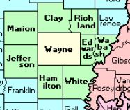 |
Edwards | |
| Franklin | Hamilton | White | |